Getting off Silver Ferry.
At around 6 am the Silver Ferry sailed into Hachinohe port. I packed my things and went down to Silver ferry's top loading bay. My bike was parked on the top deck of the loading bay. I waited a few minutes before the main door opened and was given the green light to ride off. I as rode off I looked up into the skies and lots of rain clouds were gathering above. It might be raining, I thought.
The cycling from Hachinohe to Sendai is going to be different. I am going to take route 45. Route 45 starts from Hachinohe and follows the Eastern Pacific of Japan to Sendai city. The route is around 400km and runs through small coastal towns and cities.
My cycling goal for today is to reach Miyako city at nightfall. Mayako city is located 120km south of Hachinoa and should take me 10-20 hours to cycle due to the mountains along the route.
I left Hachinohe around 7 am and headed to Miyako city through route 45. I reached my destination Around 12pm.
7:45 am I left Hachinohe ferry port and followed the port road towards Hachinohe line
On my route, to Miyako, I stopped by the Tanesashi Kaigan Campsite site and took this photo. Tanesashi Kaigan Campsite is located next to the ocean and it is an open green space area. At the time of the photo taken, there were few people there walking their dogs.
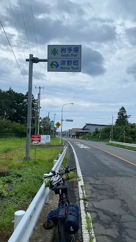
Crossing into Iwate prefecture from Aomori.100m ahead is the small town of Hironori.
A beautiful beach along the Hamakaze road in Dai village.
The picture was taken at Hirono city hall. Behind the signboard are the car park and the city hall office building.
Destination Miyako 114km .Took this picture after a left Hirono city.
This is Tofuguara Park located on the coastline of Noda city. Tofuguara Park covers a pretty large area of the city along its coastline. It has small shelters, benches, and a few sculptures. An amazing breathtaking spot.
The rocky coastline of Tamagawa in Nida city along route 45. I took this photo as I passed through Noda, heading toward Fudai city.
Heading out of Fudai city I came onto Sanriku Railway Osawa Bridge. The view is so mesmerizing, it made me stop to take this photo. In the background are a small fishing harbor and steep cliffs
After Fudai I cycled for 40 km and I reached the town of Ichinowateri. This signpost let me know this is Ichinowateri territory.
At Tanohata in Iwate prefecture, I climbed one of the longest slopes in my journal so far. At that time, the set was slowing setting as I made my way up. Few places along the track I have to push my bike and walk. When I took this photo I was exhausted and wanted to take a rest.
After reaching the outskate of Tanohata town and stopping to take a breather I took this beautiful photo at the Shituiohashi Parking lot just before crossing the Shii Bridge.
What a marvel of Japanese Engineering. The Shianzakao Bridge was built in 1995 to replace the old one. It is at least 120m high and 105 m in length. It is one of Iwate's prefecture's main tourist attractions. I'm so glad to have visited this bridge.
Destination: Miyako city 37km more to go. 300m ahead is the famous Unosu Cliff. I tried to cycle there but it was too far and I don't enough have time because it was getting dark.
On road to Miyako
Route 45 is smaller than route 4 and runs from Hachinohe to Sendai through the eastern seaboard of Japan. Route 4 is the one I took to Hokkaido. There are fewer cars on route 45 and it passes through beautiful coastal towns, amazing mountains, and stunning ocean views.
Along the way, I passed through many small villages and climbed many mountains. This route was much more difficult than route 4 because I spend a lot of hours climbing the mountains. I was so tired. I have to walk up mountains. I tried to travel light, but my backpack and tool bag still added an extra 10kg onto my bike.
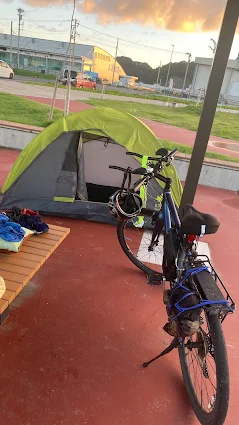
From Hachinohe to Miyako it took me almost 18 hours of cycling over a distance of 150km. I left Hachinohe at 7am and reached Miyako at around 12pm. I planned to find a camping ground for my overnight stay at Miyako but could not. So, after arriving there I just went to a park and set up my tent. People were walking around but I was so tired I just lay on the bench and soon fell asleep.

After passing through the small town of Omota. I stopped at this beautiful lookout along route 45 to relax my feet. By now my destination is less than 20km ahead.
6:45 pm the day finally coming to the end. I am now in Miyoka nearing my destination. I took this photo in a place called Taro. The setting sun was so beautiful as I cycled up the slope. It was a sight I will never forget.
I took the opportunity of the night to crash at Michi park. The park is located next to a harbor and away from the main city of Miyako.
4:58am at Michi park. The first sunlight of a new day of my cycling to my next destination Kesenuma City in Miyaki prefecture. The morning sunset was so beautiful I took a few minutes to observe it.


No comments:
Post a Comment